The geomagnetic method is used to measure components of the Earth’s magnetic field (vertical, horizontal, and total) or variations in the intensity of this field. These variations allow for the differentiation between magnetized and non-magnetized objects. The method is sensitive to variations in magnetic susceptibility (resulting from changes in induced magnetization) as well as the presence of thermoremanent or viscous magnetization. While remanent magnetization plays a negligible role in the detection of archaeological artifacts, thermoremanent magnetization is a primary factor. For instance, clay—a raw material for ceramics frequently found at archaeological sites—acquires magnetic properties during the processes of heating and cooling (Figure 1).
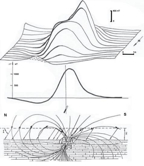
Figure 1: Schematic of the formation of a magnetic anomaly over a buried kiln (Smekalova et al., 2008).
In geomagnetic surveys conducted as part of shallow geophysical investigations, the most significant factor is the variation in the magnetic properties of the soil. Many researchers have extensively studied the transformation of iron oxides—which alters the magnetic properties of soil—and the oxidation processes that drive these changes. Furthermore, the transformation of iron oxides resulting from bacterial reduction within the soil is also a subject of research. Additionally, it has been observed that certain rock units, due to their high iron oxide content, may undergo chemical alterations—sometimes referred to as “fermentation” in this context—which also contribute to the transformation of iron oxides. In general, materials such as clay, ceramics, or hearth structures that have been subjected to burning as a result of human activity acquire thermoremanent magnetization.
This situation is one of the primary causes of anomalies in magnetic prospection for archaeological purposes. Features and materials such as pits, trenches, walls, roads, voids, and iron objects are commonly encountered at archaeological sites. These features and materials acquire magnetic properties either due to their inherent magnetic susceptibility values or through thermoremanent magnetization—a form of permanent magnetism gained as a result of exposure to heat. Over time, such features become filled with soil, either through natural processes or human intervention. Depending on the characteristics of the infill material, these filled areas will exhibit a distinct magnetic susceptibility. In archaeological contexts, pits used for refuse disposal, for instance, may contain organic matter that undergoes decomposition, leading to the development of strong magnetic properties—thereby making them detectable. Furthermore, such features may have been subjected to fire, which can result in even higher magnetic values due to the distinct physical changes that occur. If volcanic materials were used in the construction of structures, anomalies with high magnetic values can be observed at those locations (Figure 2). Iron possesses a very high magnetic susceptibility; in archaeological surveys—particularly when the goal is to map settlement layouts—this often leads to problematic or misleading results. Conversely, if the specific targets of a survey are iron objects, they can be easily detected using various types of magnetometers. Another drawback of iron-based objects is that they produce extremely sharp and poorly defined anomalies. If modern iron debris is prevalent within the study area, it can severely compromise the integrity of the research, potentially rendering it impossible to derive any meaningful results. In such a situation, it is recommended—if feasible—to remove a layer of soil from the surface, clear the area of any such ferrous objects, and subsequently continue the investigations (Drahor, 2007).
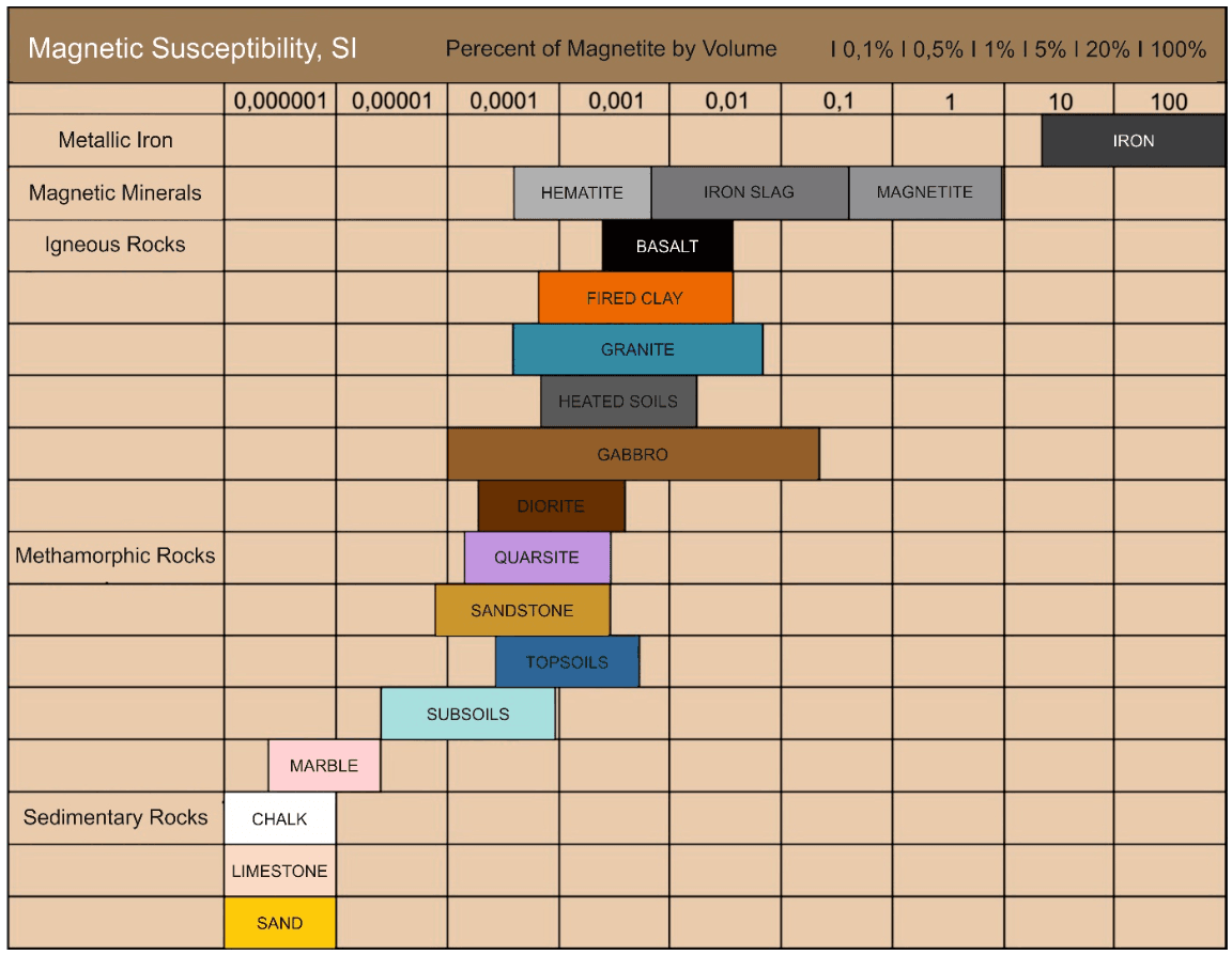
Figure 2: Magnetic susceptibilities of some rocks (Smekalova et al., 2008).
Given that certain archaeological features produce magnetic anomalies on the order of a few nT (nanoteslas), the sensitivity of the instruments used in such investigations is of critical importance. Thanks to technological advancements, it is now possible to survey and visualize an area of several hectares in a single day using magnetic instruments. Consequently, the magnetic method offers archaeologists two significant advantages: shorter excavation durations and reduced excavation costs. Collecting magnetic data from archaeological sites is a relatively straightforward process. It begins by establishing a grid over the study area, tailored to the specific research objectives. Once the area is gridded, measurements can be taken using an appropriate magnetometer to acquire the necessary data. Further details regarding the collection of geophysical data over such gridded areas are provided by Drahor (2006). In archaeological research, fluxgate and cesium gradiometers are commonly employed. These instruments typically feature fixed sensor spacing, high sensitivity, and the capability for rapid data acquisition. Using such a gradiometer, an area exceeding several hectares can be easily surveyed and visualized in a single day (Drahor, 2006).
One of the most crucial factors in identifying buried archaeological structures is the application of appropriate evaluation and visualization techniques. The magnetic field measured at any given point encompasses the combined influence of all structures present—from the surface down to depth. Therefore, the height at which the sensor is positioned is highly significant for detecting the intended target; furthermore, by subjecting the collected data to suitable signal analysis techniques, the target can be identified with much greater precision. Although magnetic data collected from an archaeological site primarily reflect the influence of shallow-depth targets, the application of filtering techniques—such as low-pass, high-pass, or band-pass filters—can facilitate qualitative interpretations regarding the depth of these features. Furthermore, a variety of other signal analysis methods can be employed in the evaluation of magnetic data, including upward and downward analytical continuation, reduction to the magnetic north pole, inverse filtering, and power spectrum analysis. Visualization techniques play a crucial role in the interpretation of such data. Through processes such as pixel analysis, the delineation of anomaly boundaries, the reduction of blur, and the application of shading and relief-lighting effects, the data can be refined into an optimal, more “photographic” representation. Such techniques are highly significant for enhancing the image quality of magnetic data acquired from archaeological sites and for achieving more effective subsurface visualization (Drahor, 2006).